Aviation Weather Services 2
Paid Version
Publisher Description
Aviation Weather Services - Aviation Weather Services Advisory Circular, AC 00-45G, Change 1
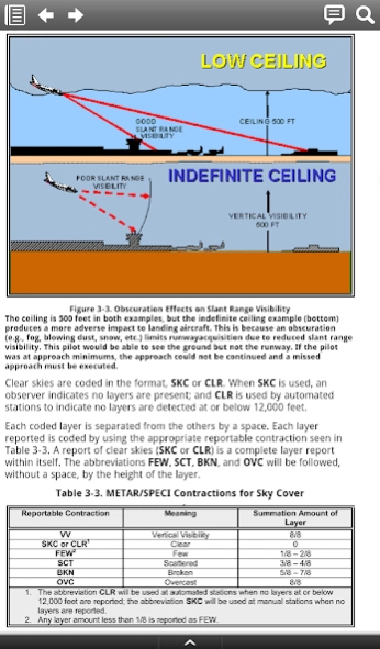
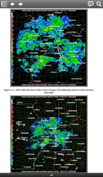
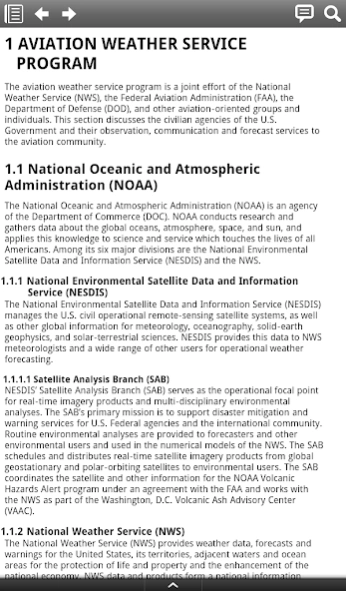
Aviation Weather Services, Advisory Circular 00-45G, Change 1, is published jointly by the National Weather Service (NWS) and the Federal Aviation Administration (FAA). AC 00-45G, Change 1, explains U.S. aviation weather products and services. It details the interpretation and application of advisories, coded weather reports, forecasts, observed and prognostic weather charts, and radar and satellite imagery. Product examples and explanations are taken primarily from the Aviation Weather Center’s Aviation Digital Data Service. Aviation Weather Services, Advisory Circular, AC 00-45G, Change 1, supersedes AC 00-45G. Chapters includes: AVIATION WEATHER SERVICE PROGRAM, NATIONAL OCEANIC and ATMOSPHERIC ADMINISTRATION (NOAA), FEDERAL AVIATION ADMINISTRATION, DISSEMINATION of AVIATION WEATHER PRODUCTS, AVIATION WEATHER PRODUCT CLASSIFICATION AND POLICY, CLASSIFICATION of AVIATION WEATHER PRODUCTS, Types of AVIATION WEATHER INFORMATION, AVIATION ROUTINE WEATHER REPORTS (METAR) and AVIATION SELECTED SPECIAL WEATHER REPORTS (SPECI), METAR/SPECI Type and Frequency of Lightning, PILOT WEATHER REPORTS (PIREP), RADAR WEATHER REPORT (SD/ROB), RADAR AND SATELLITE IMAGERY, SATELLITE, GRAPHICAL OBSERVATIONS, SURFACE ANALYSIS CHARTS, FREEZING-LEVEL GRAPHICS, RADAR SUMMARY CHART, PRODUCTS FOR AVIATION HAZARDS, CENTER WEATHER ADVISORY (CWA), TROPICAL CYCLONES, VOLCANIC ASH ADVISORY PRODUCTS, TERMINAL AERODROME FORECAST, INTERNATIONAL AVIATION ROUTE FORECASTS, FORECAST CHARTS, LOW-LEVEL SIGNIFICANT WEATHER (SIGWX) CHARTS, HIGH-LEVEL SIGNIFICANT WEATHER, NATIONAL CONVECTIVE WEATHER FORECAST, CURRENT ICING PRODUCT, FORECAST ICING POTENTIAL, GRAPHICAL TURBULENCE GUIDANCE, METEOROLOGICAL IMPACT STATEMENT, DEFINITION OF COMMON TERMS USED IN EN ROUTE FORECASTS AND ADVISORIES, STANDARD CONVERSION CHART, DENSITY ALTITUDE CALCULATION, ADVISORY PLOTTING CHART, WEATHER RADAR NETWORK, GEOGRAPHICAL AREA DESIGNATOR MAP, PRESENT WEATHER SYMBOLS, TURBULENCE AND ICING INTENSITY DEPICTIONS.
About Aviation Weather Services
Aviation Weather Services is a paid app for Android published in the Reference Tools list of apps, part of Education.
The company that develops Aviation Weather Services is Mepcount Media LLC. The latest version released by its developer is 2.
To install Aviation Weather Services on your Android device, just click the green Continue To App button above to start the installation process. The app is listed on our website since 2013-08-27 and was downloaded 23 times. We have already checked if the download link is safe, however for your own protection we recommend that you scan the downloaded app with your antivirus. Your antivirus may detect the Aviation Weather Services as malware as malware if the download link to com.mepcount.Aviation_Weather_Services is broken.
How to install Aviation Weather Services on your Android device:
- Click on the Continue To App button on our website. This will redirect you to Google Play.
- Once the Aviation Weather Services is shown in the Google Play listing of your Android device, you can start its download and installation. Tap on the Install button located below the search bar and to the right of the app icon.
- A pop-up window with the permissions required by Aviation Weather Services will be shown. Click on Accept to continue the process.
- Aviation Weather Services will be downloaded onto your device, displaying a progress. Once the download completes, the installation will start and you'll get a notification after the installation is finished.
